|
|
| PO BOX 342 |
|
| SAXAPAHAW , NC 27340 |
|
| Property
Location Address |
|
| Parcel
ID No. |
13189 |
| PIN |
4525 05 28 3416 |
| |
|
| Owner ID |
1002986 |
| |
|
| Tax
District |
156 - COUNTY/CITY OF KINSTON |
| |
| Land Use Code |
D |
| Land Use Desc |
RES - IMP |
| |
|
| Neighborhood |
0232 |
|
| Legal
Desc |
405 W HIGHLAND AV |
| |
2 UNITS THIS BLDG/2BR/1 B |
| |
|
| Deed
Year Bk/Pg |
2017 - 1807 / 541 |
| Plat
Bk/Pg |
M2 / 61 |
| |
Sales
Information |
| |
| Grantor |
BRYAN JEANNINE A |
| |
|
| Sold
Date |
2022-03-04 |
| Sold
Amount $ |
207,500 |
|
| |
| Market Value $ |
89,043
|
| |
|
Market
Value - Land and all permanent improvements,
if any, effective January 1, 2017, date
of County’s most recent General Reappraisal
|
|
| |
|
| Assessed Value $ |
89,043
|
| |
If
Assessed Value not equal Market Value then
subject parcel designated as a special
class -agricultural, horticultural, or
forestland and thereby eligible for taxation
on basis of Present-Use.
|
|
|
| Year
Built |
1995 |
| Built
Use/Style |
DUPLEX/TRIPLEX |
| Grade |
C / |
| * Percent
Complete |
100 |
| Heated
Area (S/F) |
2,030 |
| Fireplace
(Y/N) |
N |
| Basement
(Y/N) |
N |
| ** Bedroom(s) |
0 |
| ** Bathroom(s) |
0 Full Bath(s) 0 Half Bath(s) |
| *** Multiple
Improvements |
002 |
*
Note - As of January 1
*
* Note - Bathroom(s), Bedroom(s), shown for description
only
* * * Note - If multiple improvements equal “MLT” then
parcel includes additional major improvements |
|
| Building
Sketch - NOTE: Sketches are updated the first day of every month. |
|
(Building 1) - Sketch for Parcel ID: 13189
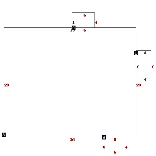 |
| Label |
Description |
Base SF |
Total SF |
| A |
DUPLEX/TRIPLEX |
1015.00 |
2030.00 |
| B |
PORCH |
24.00 |
24.00 |
| C |
PORCH |
24.00 |
24.00 |
| D |
PORCH |
28.00 |
28.00 |
|
|
(Building 2) - Sketch for Parcel ID: 13189
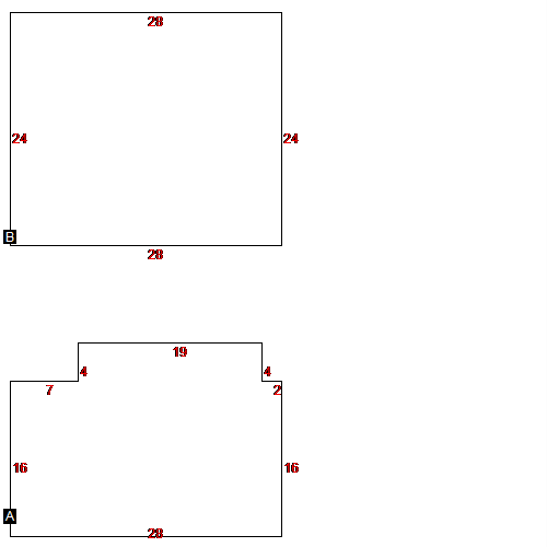 |
| Label |
Description |
Base SF |
Total SF |
| A |
LIV AREA OVR GARAGE |
524.00 |
524.00 |
| B |
GARAGE FIN FRAME |
672.00 |
672.00 |
|
|
|
|
|
| Map Acres |
0.26 |
| Tax District Note |
156 - COUNTY/CITY OF KINSTON |
| Present-Use Info |
RES - IMP |
| Zoning Code |
RA6 |
| Zoning Desc |
RA6 |
|
| Total Improvements Valuation
|
*Total Improvements Full Market Value $
|
**Total Improvements Assessed Value
|
81,043
|
81,043
|
*
Note - Market Value effective Date equal January
1, 2017, date of County’s most recent General
Reappraisal
** Note - If Assessed Value not equal Market Value then variance
resulting from formal appeal procedure |
|
| Land
Value Detail (Effective Date January 1, 2017, date
of County’s most recent General Reappraisal) |
Land
Full Value (LFV) $
|
Land
Present-Use Value (PUV) $ **
|
Land
Total Assessed Value $
|
8,000
|
8,000
|
8,000
|
| **
Note: If PUV equal LMV then parcel has
not qualified for present use program |
|
| Land
Detail (Effective Date January 1,
2017, date of County’s
most recent General Reappraisal) |
Rate Type |
Rate Code |
Description |
Quantity |
|
|
|
|
