| KINSTON CLINIC HOLDINGS LLC |
| |
|
| 110 AVALON CIRCLE |
|
| WATERBURY , CT 06710 |
|
| Property
Location Address |
|
| Parcel
ID No. |
9926 |
| PIN |
4526 09 15 7203 |
| |
|
| Owner ID |
1009798 |
| |
Future Transfer |
| Tax
District |
156 - COUNTY/CITY OF KINSTON |
| |
| Land Use Code |
C |
| Land Use Desc |
COMM - IMP |
| |
|
| Neighborhood |
0995 |
|
| Legal
Desc |
KINSTON CLINIC NORTH |
| |
TLVA / 78,665SF |
| |
|
| Deed
Year Bk/Pg |
2019 - 1863 / 842 |
| Plat
Bk/Pg |
/ |
| |
Sales
Information |
| |
| Grantor |
KINSTON CLINIC HOLDINGS LLC |
| |
|
| Sold
Date |
2021-03-03 |
| Sold
Amount $ |
7,950,000 |
|
| |
| Market Value $ |
4,335,479
|
| |
|
Market
Value - Land and all permanent improvements,
if any, effective January 1, 2017, date
of County’s most recent General Reappraisal
|
|
| |
|
| Assessed Value $ |
4,335,479
|
| |
If
Assessed Value not equal Market Value then
subject parcel designated as a special
class -agricultural, horticultural, or
forestland and thereby eligible for taxation
on basis of Present-Use.
|
|
|
| Year
Built |
1990 |
| Built
Use/Style |
OFFICE-MEDICAL |
| Grade |
C / |
| * Percent
Complete |
100 |
| Heated
Area (S/F) |
25,163 |
| Fireplace
(Y/N) |
N |
| Basement
(Y/N) |
N |
| ** Bedroom(s) |
0 |
| ** Bathroom(s) |
0 Full Bath(s) 0 Half Bath(s) |
| *** Multiple
Improvements |
012 |
*
Note - As of January 1
*
* Note - Bathroom(s), Bedroom(s), shown for description
only
* * * Note - If multiple improvements equal “MLT” then
parcel includes additional major improvements |
|
| Building
Sketch - NOTE: Sketches are updated the first day of every month. |
|
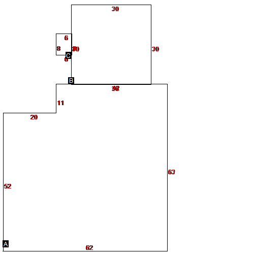
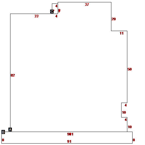
(Building 1) - Sketch for Parcel ID: 9926
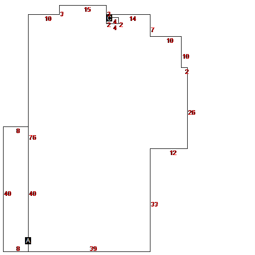 |
| Label |
Description |
Base SF |
Total SF |
| A |
OFFICE-MEDICAL |
3421.00 |
3421.00 |
| B |
CANOPY |
320.00 |
320.00 |
| C |
PORCH |
8.00 |
8.00 |
|
|
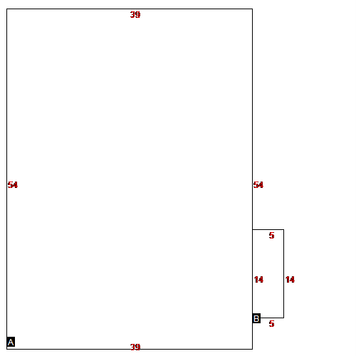
(Building 2) - Sketch for Parcel ID: 9926
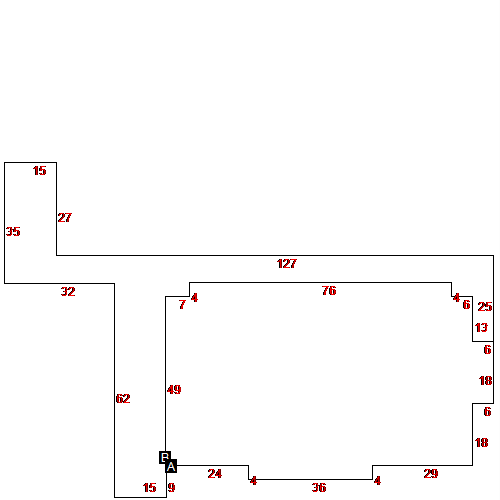 |
| Label |
Description |
Base SF |
Total SF |
| A |
OFFICE-MEDICAL |
4917.00 |
4917.00 |
| B |
CANOPY |
2625.00 |
2625.00 |
|
|
(Building 3) - Sketch for Parcel ID: 9926
 |
| Label |
Description |
Base SF |
Total SF |
| A |
COMMERCIAL |
2805.00 |
2805.00 |
|
|
(Building 4) - Sketch for Parcel ID: 9926
 |
| Label |
Description |
Base SF |
Total SF |
| A |
OFFICE-MEDICAL |
4089.00 |
4089.00 |
|
|
(Building 5) - Sketch for Parcel ID: 9926
 |
| Label |
Description |
Base SF |
Total SF |
| A |
OFFICE-MEDICAL |
3686.00 |
3686.00 |
| B |
OFFICE-MEDICAL |
900.00 |
900.00 |
| C |
PORCH-ENCLOSED |
48.00 |
48.00 |
|
|
(Building 6) - Sketch for Parcel ID: 9926
 |
| Label |
Description |
Base SF |
Total SF |
| A |
OFFICE-MEDICAL |
2106.00 |
2106.00 |
| B |
OFFICE-MEDICAL |
70.00 |
70.00 |
|
|
(Building 7) - Sketch for Parcel ID: 9926
 |
| Label |
Description |
Base SF |
Total SF |
| A |
OFFICE-MEDICAL |
7013.00 |
7013.00 |
| B |
CANOPY |
5788.00 |
5788.00 |
|
|
(Building 8) - Sketch for Parcel ID: 9926
 |
| Label |
Description |
Base SF |
Total SF |
| A |
OFFICE-MEDICAL |
3212.00 |
3212.00 |
| B |
OFFICE-MEDICAL |
352.00 |
352.00 |
|
|
(Building 9) - Sketch for Parcel ID: 9926
 |
| Label |
Description |
Base SF |
Total SF |
| A |
OFFICE-MEDICAL |
6766.00 |
6766.00 |
| B |
CANOPY |
728.00 |
728.00 |
| C |
UTILITY BRICK |
28.00 |
28.00 |
|
|
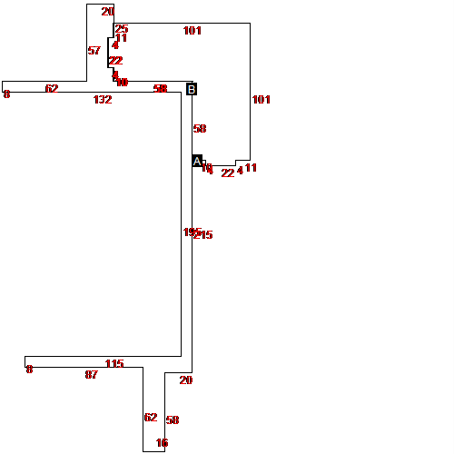
(Building 10) - Sketch for Parcel ID: 9926
 |
| Label |
Description |
Base SF |
Total SF |
| A |
OFFICE-MEDICAL |
11714.00 |
11714.00 |
|
|
(Building 11) - Sketch for Parcel ID: 9926
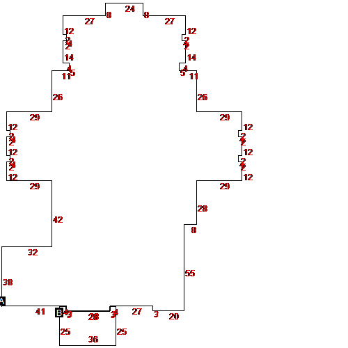 |
| Label |
Description |
Base SF |
Total SF |
| A |
OFFICE-MEDICAL |
20130.00 |
25163.00 |
| B |
CARPORT ATTACHED |
816.00 |
816.00 |
|
|
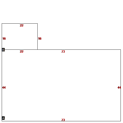
(Building 12) - Sketch for Parcel ID: 9926
 |
| Label |
Description |
Base SF |
Total SF |
| A |
OFFICE-MEDICAL |
2451.00 |
2451.00 |
| B |
CANOPY |
344.00 |
344.00 |
|
|
|
|
|
| Map Acres |
13.74 |
| Tax District Note |
156 - COUNTY/CITY OF KINSTON |
| Present-Use Info |
COMM - IMP |
| Zoning Code |
|
| Zoning Desc |
|
|
| Total Improvements Valuation
|
*Total Improvements Full Market Value $
|
**Total Improvements Assessed Value
|
4,114,679
|
4,114,679
|
*
Note - Market Value effective Date equal January
1, 2017, date of County’s most recent General
Reappraisal
** Note - If Assessed Value not equal Market Value then variance
resulting from formal appeal procedure |
|
| Land
Value Detail (Effective Date January 1, 2017, date
of County’s most recent General Reappraisal) |
Land
Full Value (LFV) $
|
Land
Present-Use Value (PUV) $ **
|
Land
Total Assessed Value $
|
220,800
|
220,800
|
220,800
|
| **
Note: If PUV equal LMV then parcel has
not qualified for present use program |
|
| Land
Detail (Effective Date January 1,
2017, date of County’s
most recent General Reappraisal) |
Rate Type |
Rate Code |
Description |
Quantity |
|
|
|
|
