| THIGPEN JUSTIN |
| THIGPEN HEATHER |
|
| 291 JOE NUNN RD |
|
| KINSTON , NC 28504 |
|
| Property
Location Address |
|
| Parcel
ID No. |
18099 |
| PIN |
4503 00 94 2666 |
| |
|
| Owner ID |
1010784 |
| |
|
| Tax
District |
128 - COUNTY/SANDY BOTTOM FIRE |
| |
| Land Use Code |
D |
| Land Use Desc |
RES - IMP |
| |
|
| Neighborhood |
0038 |
|
| Legal
Desc |
SR 1149 |
| |
291 JOE NUNN RD |
| |
|
| Deed
Year Bk/Pg |
2019 - 1873 / 431 |
| Plat
Bk/Pg |
/ |
| |
Sales
Information |
| |
| Grantor |
CARTER TILLMAN E & ANGELA H |
| |
|
| Sold
Date |
2019-12-27 |
| Sold
Amount $ |
202,000 |
|
| |
| Market Value $ |
189,925
|
| |
|
Market
Value - Land and all permanent improvements,
if any, effective January 1, 2017, date
of County’s most recent General Reappraisal
|
|
| |
|
| Assessed Value $ |
189,925
|
| |
If
Assessed Value not equal Market Value then
subject parcel designated as a special
class -agricultural, horticultural, or
forestland and thereby eligible for taxation
on basis of Present-Use.
|
|
|
| Year
Built |
1984 |
| Built
Use/Style |
|
| Grade |
B-5 / |
| * Percent
Complete |
100 |
| Heated
Area (S/F) |
3,080 |
| Fireplace
(Y/N) |
Y |
| Basement
(Y/N) |
N |
| ** Bedroom(s) |
4 |
| ** Bathroom(s) |
3 Full Bath(s) 0 Half Bath(s) |
| *** Multiple
Improvements |
001 |
*
Note - As of January 1
*
* Note - Bathroom(s), Bedroom(s), shown for description
only
* * * Note - If multiple improvements equal “MLT” then
parcel includes additional major improvements |
|
| Building
Sketch - NOTE: Sketches are updated the first day of every month. |
|
(Building 1) - Sketch for Parcel ID: 18099
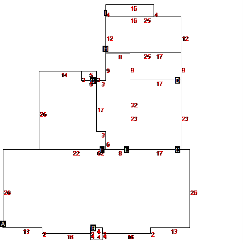 |
| Label |
Description |
Base SF |
Total SF |
| A |
SINGLE FAMILY RES |
1676.00 |
1676.00 |
| B |
PORCH |
16.00 |
16.00 |
| C |
CARPORT ATTACHED |
391.00 |
391.00 |
| D |
UTILITY FRAME |
153.00 |
153.00 |
| E |
SEMI-FINISHED LIV AREA |
307.00 |
307.00 |
| F |
SINGLE FAMILY RES |
497.00 |
497.00 |
| G |
PORCH |
15.00 |
15.00 |
| H |
SINGLE FAMILY RES |
300.00 |
600.00 |
| I |
WOOD DECK |
64.00 |
64.00 |
|
|
|
|
|
| Map Acres |
1.3 |
| Tax District Note |
128 - COUNTY/SANDY BOTTOM FIRE |
| Present-Use Info |
RES - IMP |
| Zoning Code |
|
| Zoning Desc |
|
|
| Total Improvements Valuation
|
*Total Improvements Full Market Value $
|
**Total Improvements Assessed Value
|
173,725
|
173,725
|
*
Note - Market Value effective Date equal January
1, 2017, date of County’s most recent General
Reappraisal
** Note - If Assessed Value not equal Market Value then variance
resulting from formal appeal procedure |
|
| Land
Value Detail (Effective Date January 1, 2017, date
of County’s most recent General Reappraisal) |
Land
Full Value (LFV) $
|
Land
Present-Use Value (PUV) $ **
|
Land
Total Assessed Value $
|
16,200
|
16,200
|
16,200
|
| **
Note: If PUV equal LMV then parcel has
not qualified for present use program |
|
| Land
Detail (Effective Date January 1,
2017, date of County’s
most recent General Reappraisal) |
Rate Type |
Rate Code |
Description |
Quantity |
|
|
|
|
