|
|
| 102 FORBES ST |
|
| LAGRANGE , NC 28551 |
|
| Property
Location Address |
|
| Parcel
ID No. |
16773 |
| PIN |
3557 20 80 0179 |
| |
|
| Owner ID |
1011159 |
| |
|
| Tax
District |
155 - COUNTY/TOWN OF LAGRANGE |
| |
| Land Use Code |
C |
| Land Use Desc |
COMM - IMP |
| |
|
| Neighborhood |
0997 |
|
| Legal
Desc |
SASSER LUMBER COMPANY |
| |
60X109 WHSE ON LH28958 |
| |
|
| Deed
Year Bk/Pg |
2020 - 1879 / 728 |
| Plat
Bk/Pg |
/ |
| |
Sales
Information |
| |
| Grantor |
SASSER STEVEN R |
| |
|
| Sold
Date |
2020-03-26 |
| Sold
Amount $ |
275,000 |
|
| |
| Market Value $ |
236,204
|
| |
|
Market
Value - Land and all permanent improvements,
if any, effective January 1, 2017, date
of County’s most recent General Reappraisal
|
|
| |
|
| Assessed Value $ |
236,204
|
| |
If
Assessed Value not equal Market Value then
subject parcel designated as a special
class -agricultural, horticultural, or
forestland and thereby eligible for taxation
on basis of Present-Use.
|
|
|
| Year
Built |
1972 |
| Built
Use/Style |
WAREHOUSE STORAGE |
| Grade |
D / |
| * Percent
Complete |
100 |
| Heated
Area (S/F) |
10,000 |
| Fireplace
(Y/N) |
N |
| Basement
(Y/N) |
N |
| ** Bedroom(s) |
0 |
| ** Bathroom(s) |
0 Full Bath(s) 0 Half Bath(s) |
| *** Multiple
Improvements |
002 |
*
Note - As of January 1
*
* Note - Bathroom(s), Bedroom(s), shown for description
only
* * * Note - If multiple improvements equal “MLT” then
parcel includes additional major improvements |
|
| Building
Sketch - NOTE: Sketches are updated the first day of every month. |
|
(Building 1) - Sketch for Parcel ID: 16773
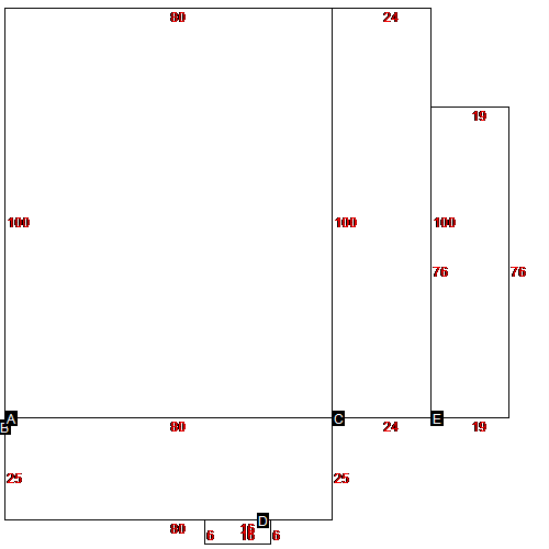 |
| Label |
Description |
Base SF |
Total SF |
| A |
WAREHOUSE STORAGE |
8000.00 |
8000.00 |
| B |
RETAIL STORE |
2000.00 |
2000.00 |
| C |
CANOPY |
2400.00 |
2400.00 |
| D |
CANOPY |
96.00 |
96.00 |
| E |
CANOPY |
1444.00 |
1444.00 |
|
|
(Building 2) - Sketch for Parcel ID: 16773
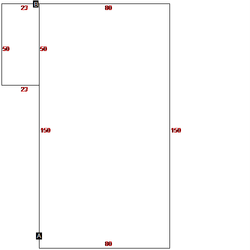 |
| Label |
Description |
Base SF |
Total SF |
| A |
WAREHOUSE STORAGE |
12000.00 |
12000.00 |
| B |
CANOPY |
1150.00 |
1150.00 |
|
|
|
|
|
| Map Acres |
6.6 |
| Tax District Note |
155 - COUNTY/TOWN OF LAGRANGE |
| Present-Use Info |
COMM - IMP |
| Zoning Code |
HC |
| Zoning Desc |
HC |
|
| Total Improvements Valuation
|
*Total Improvements Full Market Value $
|
**Total Improvements Assessed Value
|
186,704
|
186,704
|
*
Note - Market Value effective Date equal January
1, 2017, date of County’s most recent General
Reappraisal
** Note - If Assessed Value not equal Market Value then variance
resulting from formal appeal procedure |
|
| Land
Value Detail (Effective Date January 1, 2017, date
of County’s most recent General Reappraisal) |
Land
Full Value (LFV) $
|
Land
Present-Use Value (PUV) $ **
|
Land
Total Assessed Value $
|
49,500
|
49,500
|
49,500
|
| **
Note: If PUV equal LMV then parcel has
not qualified for present use program |
|
| Land
Detail (Effective Date January 1,
2017, date of County’s
most recent General Reappraisal) |
Rate Type |
Rate Code |
Description |
Quantity |
|
|
|
|
