| ASHTON ROBERT K |
| ASHTON PAMELA TYNDALL |
|
| 3035 FRED EVERETT RD |
|
| LAGRANGE , NC 28551 |
|
| Property
Location Address |
|
| Parcel
ID No. |
21628 |
| PIN |
4554 00 25 4893 |
| |
|
| Owner ID |
1011548 |
| |
Future Transfer |
| Tax
District |
134 - COUNTY/WYSE FORK FIRE |
| |
| Land Use Code |
D |
| Land Use Desc |
RES - IMP |
| |
|
| Neighborhood |
0026 |
|
| Legal
Desc |
SR 1808 LOT 1 |
| |
2900 TILGHMAN RD |
| |
|
| Deed
Year Bk/Pg |
2020 - 1885 / 72 |
| Plat
Bk/Pg |
13 / 319 |
| |
Sales
Information |
| |
| Grantor |
ASHTON ROBERT K |
| |
ASHTON PAMELA TYNDALL |
| Sold
Date |
2021-12-03 |
| Sold
Amount $ |
265,000 |
|
| |
| Market Value $ |
102,634
|
| |
|
Market
Value - Land and all permanent improvements,
if any, effective January 1, 2017, date
of County’s most recent General Reappraisal
|
|
| |
|
| Assessed Value $ |
102,634
|
| |
If
Assessed Value not equal Market Value then
subject parcel designated as a special
class -agricultural, horticultural, or
forestland and thereby eligible for taxation
on basis of Present-Use.
|
|
|
| Year
Built |
1964 |
| Built
Use/Style |
|
| Grade |
C / |
| * Percent
Complete |
100 |
| Heated
Area (S/F) |
1,669 |
| Fireplace
(Y/N) |
Y |
| Basement
(Y/N) |
N |
| ** Bedroom(s) |
3 |
| ** Bathroom(s) |
1 Full Bath(s) 1 Half Bath(s) |
| *** Multiple
Improvements |
001 |
*
Note - As of January 1
*
* Note - Bathroom(s), Bedroom(s), shown for description
only
* * * Note - If multiple improvements equal “MLT” then
parcel includes additional major improvements |
|
| Building
Sketch - NOTE: Sketches are updated the first day of every month. |
|
(Building 1) - Sketch for Parcel ID: 21628
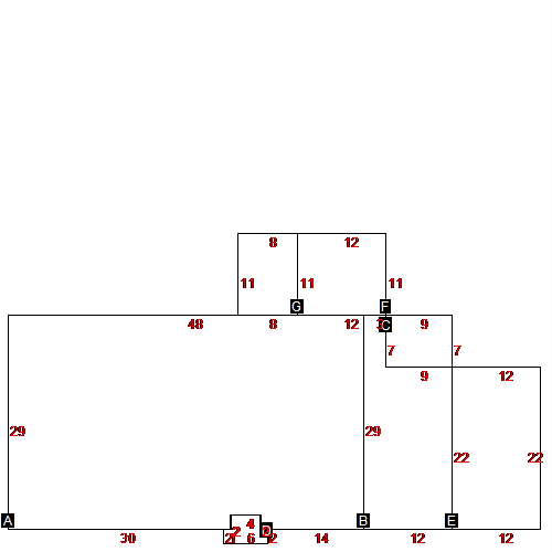 |
| Label |
Description |
Base SF |
Total SF |
| A |
SINGLE FAMILY RES |
1384.00 |
1384.00 |
| B |
SEMI-FINISHED LIV AREA |
285.00 |
285.00 |
| C |
UTILITY BRICK |
63.00 |
63.00 |
| D |
PORCH |
20.00 |
20.00 |
| E |
CARPORT ATTACHED |
264.00 |
264.00 |
| F |
PORCH |
132.00 |
132.00 |
| G |
PORCH |
88.00 |
88.00 |
|
|
|
|
|
| Map Acres |
1.21 |
| Tax District Note |
134 - COUNTY/WYSE FORK FIRE |
| Present-Use Info |
RES - IMP |
| Zoning Code |
|
| Zoning Desc |
|
|
| Total Improvements Valuation
|
*Total Improvements Full Market Value $
|
**Total Improvements Assessed Value
|
87,794
|
87,794
|
*
Note - Market Value effective Date equal January
1, 2017, date of County’s most recent General
Reappraisal
** Note - If Assessed Value not equal Market Value then variance
resulting from formal appeal procedure |
|
| Land
Value Detail (Effective Date January 1, 2017, date
of County’s most recent General Reappraisal) |
Land
Full Value (LFV) $
|
Land
Present-Use Value (PUV) $ **
|
Land
Total Assessed Value $
|
14,840
|
14,840
|
14,840
|
| **
Note: If PUV equal LMV then parcel has
not qualified for present use program |
|
| Land
Detail (Effective Date January 1,
2017, date of County’s
most recent General Reappraisal) |
Rate Type |
Rate Code |
Description |
Quantity |
|
|
|
|
