|
|
| ONE BUTTERBALL LANE |
|
| GARNER , NC 27529 |
|
| Property
Location Address |
|
| Parcel
ID No. |
15040 |
| PIN |
3558 00 59 9410 |
| |
|
| Owner ID |
13326 |
| |
|
| Tax
District |
133 - COUNTY/MOSELEY HALL FIRE |
| |
| Land Use Code |
B |
| Land Use Desc |
AGR - IMP |
| |
|
| Neighborhood |
0063 |
|
| Legal
Desc |
BEAR CREEK BREEDER FARM |
| |
173&75/100ACS LENOIR CO |
| |
|
| Deed
Year Bk/Pg |
2010 - 1618 / 877 |
| Plat
Bk/Pg |
/ |
| |
Sales
Information |
| |
| Grantor |
BUTTERBALL LLC |
| |
|
| Sold
Date |
2022-03-16 |
| Sold
Amount $ |
1,041,500 |
|
| |
| Market Value $ |
847,681
|
| |
|
Market
Value - Land and all permanent improvements,
if any, effective January 1, 2017, date
of County’s most recent General Reappraisal
|
|
| |
|
| Assessed Value $ |
847,681
|
| |
If
Assessed Value not equal Market Value then
subject parcel designated as a special
class -agricultural, horticultural, or
forestland and thereby eligible for taxation
on basis of Present-Use.
|
|
|
| Year
Built |
1954 |
| Built
Use/Style |
|
| Grade |
E / |
| * Percent
Complete |
100 |
| Heated
Area (S/F) |
1,136 |
| Fireplace
(Y/N) |
N |
| Basement
(Y/N) |
N |
| ** Bedroom(s) |
3 |
| ** Bathroom(s) |
1 Full Bath(s) 0 Half Bath(s) |
| *** Multiple
Improvements |
001 |
*
Note - As of January 1
*
* Note - Bathroom(s), Bedroom(s), shown for description
only
* * * Note - If multiple improvements equal “MLT” then
parcel includes additional major improvements |
|
| Building
Sketch - NOTE: Sketches are updated the first day of every month. |
|
(Building 1) - Sketch for Parcel ID: 15040
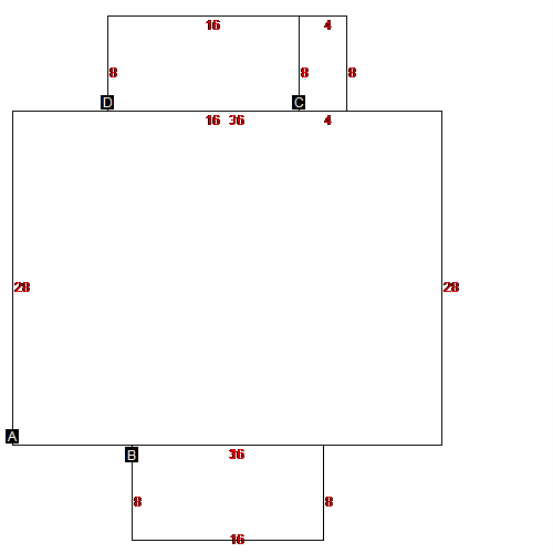 |
| Label |
Description |
Base SF |
Total SF |
| A |
SINGLE FAMILY RES |
1008.00 |
1008.00 |
| B |
PORCH |
128.00 |
128.00 |
| C |
PORCH |
32.00 |
32.00 |
| D |
SINGLE FAMILY RES |
128.00 |
128.00 |
|
|
|
|
|
| Map Acres |
347.5 |
| Tax District Note |
133 - COUNTY/MOSELEY HALL FIRE |
| Present-Use Info |
AGR - IMP |
| Zoning Code |
|
| Zoning Desc |
|
|
| Total Improvements Valuation
|
*Total Improvements Full Market Value $
|
**Total Improvements Assessed Value
|
384,556
|
384,556
|
*
Note - Market Value effective Date equal January
1, 2017, date of County’s most recent General
Reappraisal
** Note - If Assessed Value not equal Market Value then variance
resulting from formal appeal procedure |
|
| Land
Value Detail (Effective Date January 1, 2017, date
of County’s most recent General Reappraisal) |
Land
Full Value (LFV) $
|
Land
Present-Use Value (PUV) $ **
|
Land
Total Assessed Value $
|
463,125
|
463,125
|
463,125
|
| **
Note: If PUV equal LMV then parcel has
not qualified for present use program |
|
| Land
Detail (Effective Date January 1,
2017, date of County’s
most recent General Reappraisal) |
Rate Type |
Rate Code |
Description |
Quantity |
|
|
|
|
