|
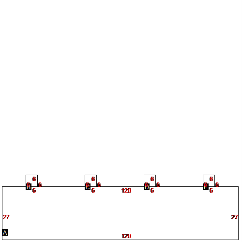
(Building 1) - Sketch for Parcel ID: 3842
 |
| Label |
Description |
Base SF |
Total SF |
| A |
MULTI-FAM APARTMNT |
3240.00 |
3240.00 |
| B |
UTILITY BRICK |
36.00 |
36.00 |
| C |
UTILITY BRICK |
36.00 |
36.00 |
| D |
UTILITY BRICK |
36.00 |
36.00 |
| E |
UTILITY BRICK |
36.00 |
36.00 |
|
|
(Building 2) - Sketch for Parcel ID: 3842
 |
| Label |
Description |
Base SF |
Total SF |
| A |
MULTI-FAM APARTMNT |
3240.00 |
3240.00 |
| B |
UTILITY BRICK |
36.00 |
36.00 |
| C |
UTILITY BRICK |
36.00 |
36.00 |
| D |
UTILITY BRICK |
36.00 |
36.00 |
| E |
UTILITY BRICK |
36.00 |
36.00 |
|
|
(Building 3) - Sketch for Parcel ID: 3842
 |
| Label |
Description |
Base SF |
Total SF |
| A |
MULTI-FAM APARTMNT |
3240.00 |
3240.00 |
| B |
UTILITY BRICK |
36.00 |
36.00 |
| C |
UTILITY BRICK |
36.00 |
36.00 |
| D |
UTILITY BRICK |
36.00 |
36.00 |
| E |
UTILITY BRICK |
36.00 |
36.00 |
|
|
(Building 4) - Sketch for Parcel ID: 3842
 |
| Label |
Description |
Base SF |
Total SF |
| A |
MULTI-FAM APARTMNT |
3240.00 |
3240.00 |
| B |
UTILITY BRICK |
36.00 |
36.00 |
| C |
UTILITY BRICK |
36.00 |
36.00 |
| D |
UTILITY BRICK |
36.00 |
36.00 |
| E |
UTILITY BRICK |
36.00 |
36.00 |
|
|
(Building 5) - Sketch for Parcel ID: 3842
 |
| Label |
Description |
Base SF |
Total SF |
| A |
MULTI-FAM APARTMNT |
3240.00 |
3240.00 |
| B |
UTILITY BRICK |
36.00 |
36.00 |
| C |
UTILITY BRICK |
36.00 |
36.00 |
| D |
UTILITY BRICK |
36.00 |
36.00 |
| E |
UTILITY BRICK |
36.00 |
36.00 |
|
|
(Building 6) - Sketch for Parcel ID: 3842
 |
| Label |
Description |
Base SF |
Total SF |
| A |
MULTI-FAM APARTMNT |
3240.00 |
3240.00 |
| B |
UTILITY BRICK |
36.00 |
36.00 |
| C |
UTILITY BRICK |
36.00 |
36.00 |
| D |
UTILITY BRICK |
36.00 |
36.00 |
| E |
UTILITY BRICK |
36.00 |
36.00 |
|
|
(Building 7) - Sketch for Parcel ID: 3842
 |
| Label |
Description |
Base SF |
Total SF |
| A |
MULTI-FAM APARTMNT |
3240.00 |
3240.00 |
| B |
UTILITY BRICK |
36.00 |
36.00 |
| C |
UTILITY BRICK |
36.00 |
36.00 |
| D |
UTILITY BRICK |
36.00 |
36.00 |
| E |
UTILITY BRICK |
36.00 |
36.00 |
|
|
(Building 8) - Sketch for Parcel ID: 3842
 |
| Label |
Description |
Base SF |
Total SF |
| A |
MULTI-FAM APARTMNT |
3240.00 |
3240.00 |
| B |
UTILITY BRICK |
36.00 |
36.00 |
| C |
UTILITY BRICK |
36.00 |
36.00 |
| D |
UTILITY BRICK |
36.00 |
36.00 |
| E |
UTILITY BRICK |
36.00 |
36.00 |
|
|
(Building 9) - Sketch for Parcel ID: 3842
 |
| Label |
Description |
Base SF |
Total SF |
| A |
MULTI-FAM APARTMNT |
3240.00 |
3240.00 |
| B |
UTILITY BRICK |
36.00 |
36.00 |
| C |
UTILITY BRICK |
36.00 |
36.00 |
| D |
UTILITY BRICK |
36.00 |
36.00 |
| E |
UTILITY BRICK |
36.00 |
36.00 |
|
|
(Building 10) - Sketch for Parcel ID: 3842
 |
| Label |
Description |
Base SF |
Total SF |
| A |
MULTI-FAM APARTMNT |
3240.00 |
3240.00 |
| B |
UTILITY BRICK |
36.00 |
36.00 |
| C |
UTILITY BRICK |
36.00 |
36.00 |
| D |
UTILITY BRICK |
36.00 |
36.00 |
| E |
UTILITY BRICK |
36.00 |
36.00 |
|
|
(Building 11) - Sketch for Parcel ID: 3842
 |
| Label |
Description |
Base SF |
Total SF |
| A |
MULTI-FAM APARTMNT |
3240.00 |
3240.00 |
| B |
UTILITY BRICK |
36.00 |
36.00 |
| C |
UTILITY BRICK |
36.00 |
36.00 |
| D |
UTILITY BRICK |
36.00 |
36.00 |
| E |
UTILITY BRICK |
36.00 |
36.00 |
|
|
(Building 12) - Sketch for Parcel ID: 3842
 |
| Label |
Description |
Base SF |
Total SF |
| A |
MULTI-FAM APARTMNT |
3240.00 |
3240.00 |
| B |
UTILITY BRICK |
36.00 |
36.00 |
| C |
UTILITY BRICK |
36.00 |
36.00 |
| D |
UTILITY BRICK |
36.00 |
36.00 |
| E |
UTILITY BRICK |
36.00 |
36.00 |
|
|
(Building 13) - Sketch for Parcel ID: 3842
 |
| Label |
Description |
Base SF |
Total SF |
| A |
MULTI-FAM APARTMNT |
3240.00 |
3240.00 |
| B |
UTILITY BRICK |
36.00 |
36.00 |
| C |
UTILITY BRICK |
36.00 |
36.00 |
| D |
UTILITY BRICK |
36.00 |
36.00 |
| E |
UTILITY BRICK |
36.00 |
36.00 |
|
|
(Building 14) - Sketch for Parcel ID: 3842
 |
| Label |
Description |
Base SF |
Total SF |
| A |
DUPLEX/TRIPLEX |
1620.00 |
1620.00 |
| B |
UTILITY BRICK |
36.00 |
36.00 |
| C |
UTILITY BRICK |
36.00 |
36.00 |
|
|
(Building 15) - Sketch for Parcel ID: 3842
 |
| Label |
Description |
Base SF |
Total SF |
| A |
DUPLEX/TRIPLEX |
1620.00 |
1620.00 |
| B |
UTILITY BRICK |
36.00 |
36.00 |
| C |
UTILITY BRICK |
36.00 |
36.00 |
|
|
(Building 16) - Sketch for Parcel ID: 3842
 |
| Label |
Description |
Base SF |
Total SF |
| A |
DUPLEX/TRIPLEX |
1620.00 |
1620.00 |
| B |
UTILITY BRICK |
36.00 |
36.00 |
| C |
UTILITY BRICK |
36.00 |
36.00 |
|
|
(Building 17) - Sketch for Parcel ID: 3842
 |
| Label |
Description |
Base SF |
Total SF |
| A |
DUPLEX/TRIPLEX |
1620.00 |
1620.00 |
| B |
UTILITY BRICK |
36.00 |
36.00 |
| C |
UTILITY BRICK |
36.00 |
36.00 |
|
|
(Building 18) - Sketch for Parcel ID: 3842
 |
| Label |
Description |
Base SF |
Total SF |
| A |
GARAGE FIN FRAME |
600.00 |
600.00 |
| B |
OFFICE-LOW COST |
264.00 |
264.00 |
|
|
|
