| FARMER N DELL PROPERTIES LLC |
| |
|
| 3407 TIMBERLAKE CT |
|
| KINSTON , NC 28504 |
|
| Property
Location Address |
|
| Parcel
ID No. |
24307 |
| PIN |
4517 04 90 5504 |
| |
|
| Owner ID |
17666 |
| |
|
| Tax
District |
156 - COUNTY/CITY OF KINSTON |
| |
| Land Use Code |
M |
| Land Use Desc |
MIXED USE |
| |
|
| Neighborhood |
0995 |
|
| Legal
Desc |
SR 1578 |
| |
FARMER/N/DELL DAYCARE |
| |
|
| Deed
Year Bk/Pg |
2014 - 1712 / 636 |
| Plat
Bk/Pg |
/ |
| |
Sales
Information |
| |
| Grantor |
|
| |
|
| Sold
Date |
2014-02-18 |
| Sold
Amount $ |
685,000 |
|
| |
| Market Value $ |
662,415
|
| |
|
Market
Value - Land and all permanent improvements,
if any, effective January 1, 2017, date
of County’s most recent General Reappraisal
|
|
| |
|
| Assessed Value $ |
662,415
|
| |
If
Assessed Value not equal Market Value then
subject parcel designated as a special
class -agricultural, horticultural, or
forestland and thereby eligible for taxation
on basis of Present-Use.
|
|
|
| Year
Built |
1975 |
| Built
Use/Style |
DAY CARE |
| Grade |
C / |
| * Percent
Complete |
100 |
| Heated
Area (S/F) |
3,312 |
| Fireplace
(Y/N) |
N |
| Basement
(Y/N) |
N |
| ** Bedroom(s) |
0 |
| ** Bathroom(s) |
0 Full Bath(s) 0 Half Bath(s) |
| *** Multiple
Improvements |
005 |
*
Note - As of January 1
*
* Note - Bathroom(s), Bedroom(s), shown for description
only
* * * Note - If multiple improvements equal “MLT” then
parcel includes additional major improvements |
|
| Building
Sketch - NOTE: Sketches are updated the first day of every month. |
|
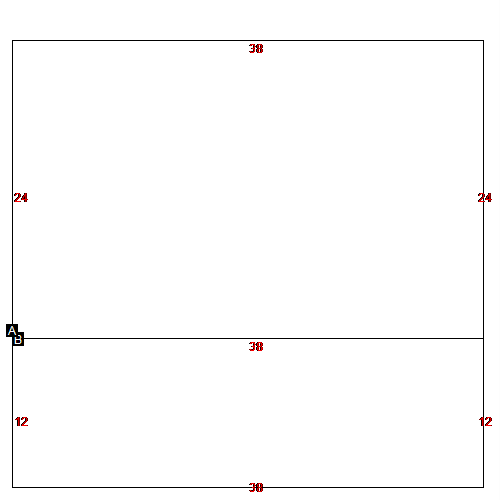
(Building 1) - Sketch for Parcel ID: 24307
 |
| Label |
Description |
Base SF |
Total SF |
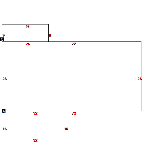
| A |
SINGLE FAMILY RES |
1470.00 |
1470.00 |
| B |
PORCH |
224.00 |
224.00 |
| C |
PORCH |
120.00 |
120.00 |
| D |
PORCH |
264.00 |
264.00 |
| E |
SINGLE FAMILY RES |
540.00 |
540.00 |
| F |
PORCH |
150.00 |
150.00 |
|
|
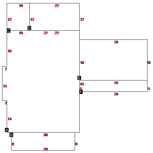
(Building 2) - Sketch for Parcel ID: 24307
 |
| Label |
Description |
Base SF |
Total SF |
| A |
DAY CARE |
1920.00 |
1920.00 |
| B |
PORCH |
300.00 |
300.00 |
| C |
PORCH |
48.00 |
48.00 |
| D |
DAY CARE |
1128.00 |
1128.00 |
| E |
DAY CARE |
264.00 |
264.00 |
|
|
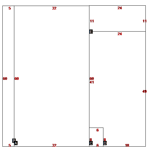
(Building 3) - Sketch for Parcel ID: 24307
 |
| Label |
Description |
Base SF |
Total SF |
| A |
DAY CARE |
2592.00 |
2592.00 |
| B |
PORCH |
512.00 |
512.00 |
| C |
CANOPY |
216.00 |
216.00 |
|
|
(Building 4) - Sketch for Parcel ID: 24307
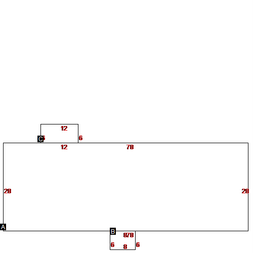 |
| Label |
Description |
Base SF |
Total SF |
| A |
MOBILE HOME |
2184.00 |
2184.00 |
| B |
WOOD DECK |
48.00 |
48.00 |
| C |
WOOD DECK |
72.00 |
72.00 |
|
|
(Building 5) - Sketch for Parcel ID: 24307
 |
| Label |
Description |
Base SF |
Total SF |
| A |
MOBILE HOME |
912.00 |
912.00 |
| B |
WOOD DECK |
456.00 |
456.00 |
|
|
|
|
|
| Map Acres |
53.3 |
| Tax District Note |
156 - COUNTY/CITY OF KINSTON |
| Present-Use Info |
MIXED USE |
| Zoning Code |
|
| Zoning Desc |
|
|
| Total Improvements Valuation
|
*Total Improvements Full Market Value $
|
**Total Improvements Assessed Value
|
564,965
|
564,965
|
*
Note - Market Value effective Date equal January
1, 2017, date of County’s most recent General
Reappraisal
** Note - If Assessed Value not equal Market Value then variance
resulting from formal appeal procedure |
|
| Land
Value Detail (Effective Date January 1, 2017, date
of County’s most recent General Reappraisal) |
Land
Full Value (LFV) $
|
Land
Present-Use Value (PUV) $ **
|
Land
Total Assessed Value $
|
97,450
|
97,450
|
97,450
|
| **
Note: If PUV equal LMV then parcel has
not qualified for present use program |
|
| Land
Detail (Effective Date January 1,
2017, date of County’s
most recent General Reappraisal) |
Rate Type |
Rate Code |
Description |
Quantity |
|
|
|
|
