| HUNSTEIN JOHN & |
| RAJCZEWSKI DOLORES |
|
| 4053 BEN DAIL RD |
|
| LAGRANGE , NC 28551 |
|
| Property
Location Address |
|
| Parcel
ID No. |
30886 |
| PIN |
3587 00 54 2411 |
| |
|
| Owner ID |
22825 |
| |
Future Transfer |
| Tax
District |
124 - COUNTY/NORTH LENIOR FIRE |
| |
| Land Use Code |
D |
| Land Use Desc |
RES - IMP |
| |
|
| Neighborhood |
0067 |
|
| Legal
Desc |
SR 1530 OFF LOTS B & C |
| |
ONLY 30FT ROAD FRTG |
| |
|
| Deed
Year Bk/Pg |
2004 - 1402 / 489 |
| Plat
Bk/Pg |
/ |
| |
Sales
Information |
| |
| Grantor |
HUNSTEIN JOHN & |
| |
RAJCZEWSKI DOLORES |
| Sold
Date |
2021-11-16 |
| Sold
Amount $ |
360,000 |
|
| |
| Market Value $ |
256,951
|
| |
|
Market
Value - Land and all permanent improvements,
if any, effective January 1, 2017, date
of County’s most recent General Reappraisal
|
|
| |
|
| Assessed Value $ |
256,951
|
| |
If
Assessed Value not equal Market Value then
subject parcel designated as a special
class -agricultural, horticultural, or
forestland and thereby eligible for taxation
on basis of Present-Use.
|
|
|
| Year
Built |
1997 |
| Built
Use/Style |
|
| Grade |
B / |
| * Percent
Complete |
100 |
| Heated
Area (S/F) |
2,473 |
| Fireplace
(Y/N) |
N |
| Basement
(Y/N) |
N |
| ** Bedroom(s) |
3 |
| ** Bathroom(s) |
3 Full Bath(s) 0 Half Bath(s) |
| *** Multiple
Improvements |
002 |
*
Note - As of January 1
*
* Note - Bathroom(s), Bedroom(s), shown for description
only
* * * Note - If multiple improvements equal “MLT” then
parcel includes additional major improvements |
|
| Building
Sketch - NOTE: Sketches are updated the first day of every month. |
|
(Building 1) - Sketch for Parcel ID: 30886
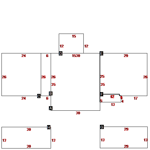 |
| Label |
Description |
Base SF |
Total SF |
| A |
SINGLE FAMILY RES |
1050.00 |
1575.00 |
| B |
SINGLE FAMILY RES |
156.00 |
156.00 |
| C |
GARAGE FIN BRICK |
624.00 |
624.00 |
| D |
PORCH-ENCLOSED |
180.00 |
180.00 |
| E |
SINGLE FAMILY RES |
742.00 |
742.00 |
| F |
STOOP |
64.00 |
64.00 |
| G |
ATTIC-UN |
377.00 |
377.00 |
| H |
ATTIC-UN |
390.00 |
390.00 |
|
|
(Building 2) - Sketch for Parcel ID: 30886
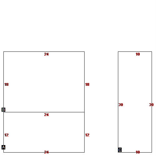 |
| Label |
Description |
Base SF |
Total SF |
| A |
SEMI-FINISHED LIV AREA |
288.00 |
288.00 |
| B |
GARAGE FIN FRAME |
432.00 |
432.00 |
| C |
LIV AREA OVR GARAGE |
300.00 |
300.00 |
|
|
|
|
|
| Map Acres |
13.08 |
| Tax District Note |
124 - COUNTY/NORTH LENIOR FIRE |
| Present-Use Info |
RES - IMP |
| Zoning Code |
|
| Zoning Desc |
|
|
| Total Improvements Valuation
|
*Total Improvements Full Market Value $
|
**Total Improvements Assessed Value
|
227,101
|
227,101
|
*
Note - Market Value effective Date equal January
1, 2017, date of County’s most recent General
Reappraisal
** Note - If Assessed Value not equal Market Value then variance
resulting from formal appeal procedure |
|
| Land
Value Detail (Effective Date January 1, 2017, date
of County’s most recent General Reappraisal) |
Land
Full Value (LFV) $
|
Land
Present-Use Value (PUV) $ **
|
Land
Total Assessed Value $
|
29,850
|
29,850
|
29,850
|
| **
Note: If PUV equal LMV then parcel has
not qualified for present use program |
|
| Land
Detail (Effective Date January 1,
2017, date of County’s
most recent General Reappraisal) |
Rate Type |
Rate Code |
Description |
Quantity |
|
|
|
|
