|
|
| 1602 CAMBRIDGE DR |
|
| KINSTON , NC 28504 |
|
| Property
Location Address |
|
| Parcel
ID No. |
37279 |
| PIN |
3591 00 93 3155 |
| |
|
| Owner ID |
26398 |
| |
|
| Tax
District |
129 - COUNTY/DEEP RUN FIRE |
| |
| Land Use Code |
D |
| Land Use Desc |
RES - IMP |
| |
|
| Neighborhood |
0004 |
|
| Legal
Desc |
SR 1141 LT 1 |
| |
SALE INCLUDES RN37280 |
| |
|
| Deed
Year Bk/Pg |
2007 - 1508 / 352 |
| Plat
Bk/Pg |
10 / 329 |
| |
Sales
Information |
| |
| Grantor |
MACKEY BRADLEY C |
| |
|
| Sold
Date |
2022-04-14 |
| Sold
Amount $ |
195,000 |
|
| |
| Market Value $ |
130,046
|
| |
|
Market
Value - Land and all permanent improvements,
if any, effective January 1, 2017, date
of County’s most recent General Reappraisal
|
|
| |
|
| Assessed Value $ |
130,046
|
| |
If
Assessed Value not equal Market Value then
subject parcel designated as a special
class -agricultural, horticultural, or
forestland and thereby eligible for taxation
on basis of Present-Use.
|
|
|
| Year
Built |
1962 |
| Built
Use/Style |
|
| Grade |
C / |
| * Percent
Complete |
100 |
| Heated
Area (S/F) |
2,000 |
| Fireplace
(Y/N) |
Y |
| Basement
(Y/N) |
N |
| ** Bedroom(s) |
3 |
| ** Bathroom(s) |
3 Full Bath(s) 0 Half Bath(s) |
| *** Multiple
Improvements |
001 |
*
Note - As of January 1
*
* Note - Bathroom(s), Bedroom(s), shown for description
only
* * * Note - If multiple improvements equal “MLT” then
parcel includes additional major improvements |
|
| Building
Sketch - NOTE: Sketches are updated the first day of every month. |
|
(Building 1) - Sketch for Parcel ID: 37279
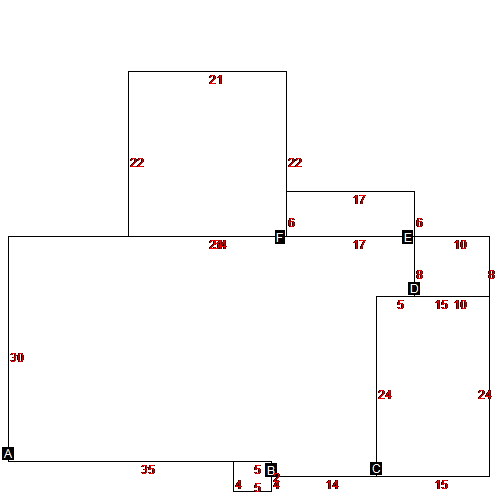 |
| Label |
Description |
Base SF |
Total SF |
| A |
SINGLE FAMILY RES |
1538.00 |
1538.00 |
| B |
PORCH |
20.00 |
20.00 |
| C |
CARPORT ATTACHED |
360.00 |
360.00 |
| D |
UTILITY BRICK |
80.00 |
80.00 |
| E |
WOOD DECK |
102.00 |
102.00 |
| F |
SINGLE FAMILY RES |
462.00 |
462.00 |
|
|
|
|
|
| Map Acres |
0.71 |
| Tax District Note |
129 - COUNTY/DEEP RUN FIRE |
| Present-Use Info |
RES - IMP |
| Zoning Code |
|
| Zoning Desc |
|
|
| Total Improvements Valuation
|
*Total Improvements Full Market Value $
|
**Total Improvements Assessed Value
|
116,201
|
116,201
|
*
Note - Market Value effective Date equal January
1, 2017, date of County’s most recent General
Reappraisal
** Note - If Assessed Value not equal Market Value then variance
resulting from formal appeal procedure |
|
| Land
Value Detail (Effective Date January 1, 2017, date
of County’s most recent General Reappraisal) |
Land
Full Value (LFV) $
|
Land
Present-Use Value (PUV) $ **
|
Land
Total Assessed Value $
|
13,845
|
13,845
|
13,845
|
| **
Note: If PUV equal LMV then parcel has
not qualified for present use program |
|
| Land
Detail (Effective Date January 1,
2017, date of County’s
most recent General Reappraisal) |
Rate Type |
Rate Code |
Description |
Quantity |
|
|
|
|
