|
|
| 132 BROADLEAF DR |
|
| JACKSONVILLE , NC 28546 |
|
| Property
Location Address |
|
| Parcel
ID No. |
26966 |
| PIN |
4526 18 41 4034 |
| |
|
| Owner ID |
34357 |
| |
|
| Tax
District |
156 - COUNTY/CITY OF KINSTON |
| |
| Land Use Code |
C |
| Land Use Desc |
COMM - IMP |
| |
|
| Neighborhood |
0995 |
|
| Legal
Desc |
1802 OLD SNOW HILL RD |
| |
DAYCARE BLDG / TRACT B |
| |
|
| Deed
Year Bk/Pg |
2015 - 1756 / 730 |
| Plat
Bk/Pg |
P5 / 93 |
| |
Sales
Information |
| |
| Grantor |
|
| |
|
| Sold
Date |
2015-09-25 |
| Sold
Amount $ |
395,000 |
|
| |
| Market Value $ |
87,259
|
| |
|
Market
Value - Land and all permanent improvements,
if any, effective January 1, 2017, date
of County’s most recent General Reappraisal
|
|
| |
|
| Assessed Value $ |
87,259
|
| |
If
Assessed Value not equal Market Value then
subject parcel designated as a special
class -agricultural, horticultural, or
forestland and thereby eligible for taxation
on basis of Present-Use.
|
|
|
| Year
Built |
1901 |
| Built
Use/Style |
DAY CARE |
| Grade |
D / |
| * Percent
Complete |
100 |
| Heated
Area (S/F) |
3,866 |
| Fireplace
(Y/N) |
N |
| Basement
(Y/N) |
N |
| ** Bedroom(s) |
0 |
| ** Bathroom(s) |
0 Full Bath(s) 0 Half Bath(s) |
| *** Multiple
Improvements |
001 |
*
Note - As of January 1
*
* Note - Bathroom(s), Bedroom(s), shown for description
only
* * * Note - If multiple improvements equal “MLT” then
parcel includes additional major improvements |
|
| Building
Sketch - NOTE: Sketches are updated the first day of every month. |
|
(Building 1) - Sketch for Parcel ID: 26966
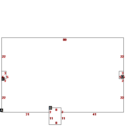 |
| Label |
Description |
Base SF |
Total SF |
| A |
DAY CARE |
3866.00 |
3866.00 |
| B |
PORCH |
88.00 |
88.00 |
| C |
PORCH |
15.00 |
15.00 |
| D |
PORCH |
15.00 |
15.00 |
|
|
|
|
|
| Map Acres |
0.53 |
| Tax District Note |
156 - COUNTY/CITY OF KINSTON |
| Present-Use Info |
COMM - IMP |
| Zoning Code |
|
| Zoning Desc |
|
|
| Total Improvements Valuation
|
*Total Improvements Full Market Value $
|
**Total Improvements Assessed Value
|
75,652
|
75,652
|
*
Note - Market Value effective Date equal January
1, 2017, date of County’s most recent General
Reappraisal
** Note - If Assessed Value not equal Market Value then variance
resulting from formal appeal procedure |
|
| Land
Value Detail (Effective Date January 1, 2017, date
of County’s most recent General Reappraisal) |
Land
Full Value (LFV) $
|
Land
Present-Use Value (PUV) $ **
|
Land
Total Assessed Value $
|
11,607
|
11,607
|
11,607
|
| **
Note: If PUV equal LMV then parcel has
not qualified for present use program |
|
| Land
Detail (Effective Date January 1,
2017, date of County’s
most recent General Reappraisal) |
Rate Type |
Rate Code |
Description |
Quantity |
|
|
|
|
